


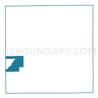
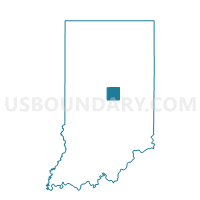
EAGLETOWN, Hamilton County, Indiana
About
Outline

Summary
| Unique Area Identifier | 577471 |
| Name | EAGLETOWN |
| County | Hamilton County |
| State | Indiana |
| Area (square miles) | 9.64 |
| Land Area (square miles) | 9.61 |
| Water Area (square miles) | 0.03 |
| % of Land Area | 99.66 |
| % of Water Area | 0.34 |
| Latitude of the Internal Point | 40.02465750 |
| Longtitude of the Internal Point | -86.19374200 |
Maps

Graphs
Select a template below for downloading or customizing gragh for EAGLETOWN, Hamilton County, Indiana


Neighbors
Neighoring Voting District (by Name) Neighboring Voting District on the Map
- CENTENNIAL 01, Hamilton County, IN
- CENTENNIAL 02, Hamilton County, IN
- CLAY NORTHWEST, Hamilton County, IN
- EAGLE 6, Boone County, IN
- HORTON, Hamilton County, IN
- JOLIET, Hamilton County, IN
- KINGSBOROUGH, Hamilton County, IN
- OAK RIDGE 01, Hamilton County, IN
- OAK RIDGE 02, Hamilton County, IN
- OAK RIDGE 03, Hamilton County, IN
- SADDLE CREEK, Hamilton County, IN
- UNION 01, Boone County, IN
- VILLAGE FARMS 03, Hamilton County, IN
- WEST WESTFIELD 02, Hamilton County, IN
Top 10 Neighboring County Subdivision (by Population) Neighboring County Subdivision on the Map
- Clay township, Hamilton County, IN (83,293)
- Washington township, Hamilton County, IN (32,884)
- Eagle township, Boone County, IN (21,977)
- Union township, Boone County, IN (2,357)
Top 10 Neighboring Place (by Population) Neighboring Place on the Map
Top 10 Neighboring Unified School District (by Population) Neighboring Unified School District on the Map
- Carmel Clay Schools, IN (83,293)
- Westfield-Washington Schools, IN (32,884)
- Zionsville Community Schools, IN (24,334)
Top 10 Neighboring State Legislative District Lower Chamber (by Population) Neighboring State Legislative District Lower Chamber on the Map
- State House District 87, IN (80,568)
- State House District 39, IN (76,305)
- State House District 38, IN (66,895)
Top 10 Neighboring State Legislative District Upper Chamber (by Population) Neighboring State Legislative District Upper Chamber on the Map
Top 10 Neighboring 111th Congressional District (by Population) Neighboring 111th Congressional District on the Map
Top 10 Neighboring Census Tract (by Population) Neighboring Census Tract on the Map
- Census Tract 1103, Hamilton County, IN (12,100)
- Census Tract 1109.03, Hamilton County, IN (9,866)
- Census Tract 1104.03, Hamilton County, IN (9,180)
- Census Tract 1104.04, Hamilton County, IN (5,114)
- Census Tract 8106.04, Boone County, IN (4,982)
- Census Tract 8106.01, Boone County, IN (4,811)
- Census Tract 1104.01, Hamilton County, IN (3,917)